“GEO4A wants to add value in the potato sector by making use of satellite based earth observations”
Marknesse, April 2019. The recently started company Geo4A based in Marknesse would like to add more value in the potato value chain by stimulating information exchange and integration of satellite based earth observations. “Our partners have access to various data and it is up to us to translate this to relevant applications in the market. Together with organizations in the potato value chain we would like to develop meaningful information”, explains Paul Oomen, Managing Director of Geo4A.
Geo4A is based at the Dyntes Tech Park across the Dutch Aerospace Centre in Marknesse. The recently started company focusses on cooperation with the potato value chain to develop relevant product and services. “We would first like to investigate the exact needs and requirements and how we can use earth observation techniques most efficiently. Our most important partner, the Austrian company GeoVille has access to a lot of satellite based earth observation data, but cannot always translate this to relevant services for the potato value chain” explains Oomen.
Oomen is a farmer’s son, and after his study at the Wageningen University gained further experience at HZPC. During his time at HZPC he was involved in the start-up of Solentum. Later he was active as Product Manager in Germany and Business Development Manager in North America. Meanwhile he is well-know in the sector. “Personally I have a great passion for the potato industry and new technologies. Because of this combination I decided to join and develop Geo4A”. The company is a spin-off from ESA’s EOPLUG-IN project which started last year in the Netherlands.
Vitality in the fields
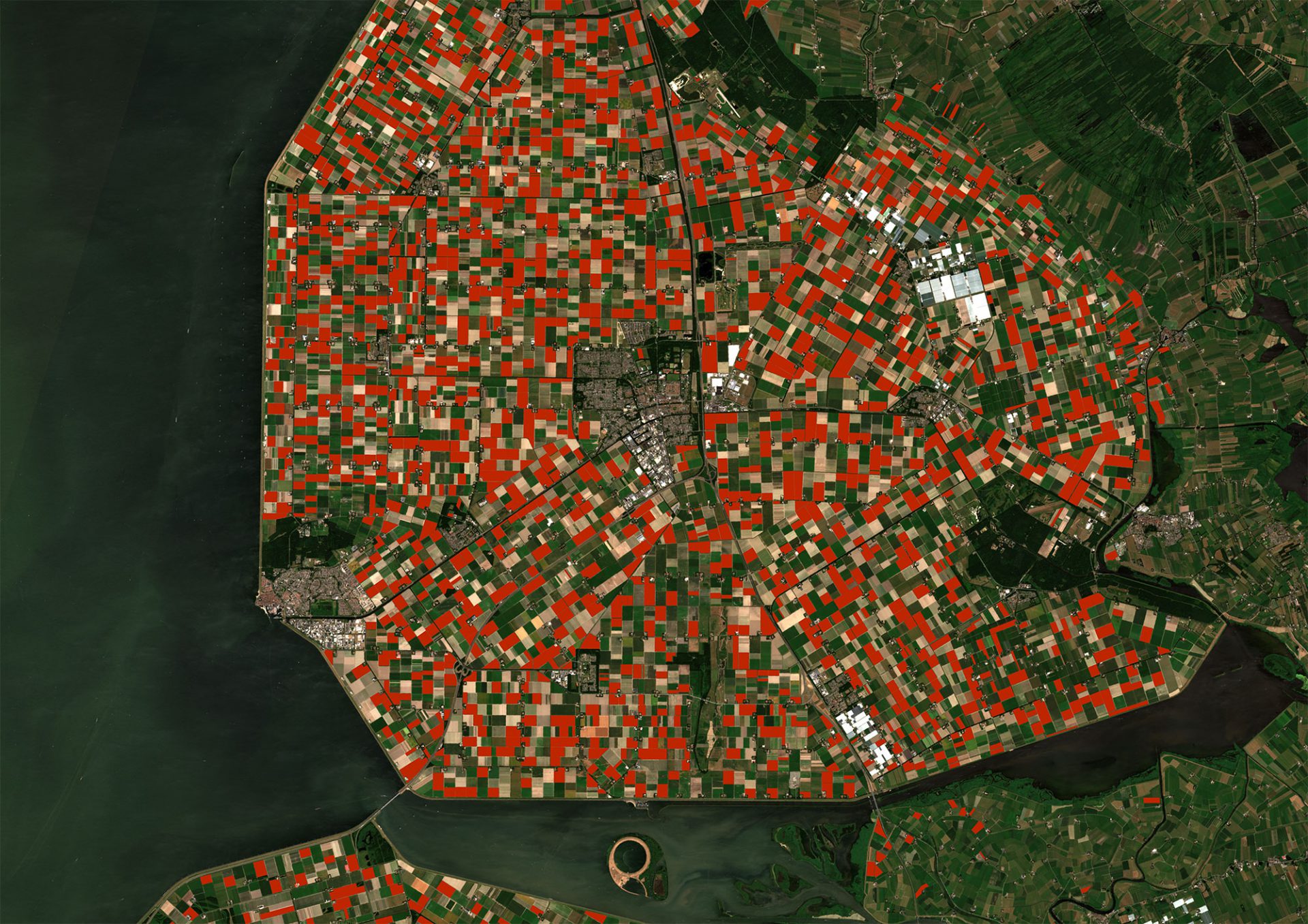
The project Oomen is referring to is a cooperation between GeoVille, Hermess, HLB and Agrico. In the project the area of the Noordoostpolder was monitored with satellites last year. “With data of the Sentinel 2 satellite we detected and monitored the potato fields closely. Also, we have observed the drought impact and measured great differences in final yields and quality” Oomen explains. “We would first like to asses the exact requirements in the potato value chain and define how can successfully work together on the development of products and services” explains Paul Oomen about the approach of Geo4A.
Acreage measurement
Oomen mentions that they measure the acreage of potato fields quite precise. “At this moment we can measure the acreage of the potato fields with an accuracy of around 90%”. Not only for the Noordoostpolder region, but potentially also for other areas in Europe. Last year we focussed on the Noordoostpolder region, to validate data. This information is for example important for the seed potato companies and the processing industry. To the question if they can detect different varieties, he answers clearly no. “However, the programmers of our partner GeoVille like challenges. If we can distinguish Innovator and Fontane, I know we have a great part of the market covered.
High demand for data
The target market of the new company are the seed potato companies and the French fry processors. These companies have a great demand for information to support their processes. Not only in the Netherlands, but worldwide. The potato sector is booming. At this moment these companies don’t know what is exactly available. Therefore we start with the assessment of what is relevant to them and how we can cooperate together on the development of product and services. We will also focus on the data integration. GeoVille successfully fulfilled 458 projects in 137 countries and gained a lot of experience with the development of algorithms, data exchange and dashboards. This helps us to develop more rapidly. At this moment we mainly work on acreage verification and plant monitoring services. Also we work on forecasting services to indicate final yields in different regions. This still needs some development time, but there is a great market ahead.


